Finland's population grew in 623 postal code areas and fell in 2,374
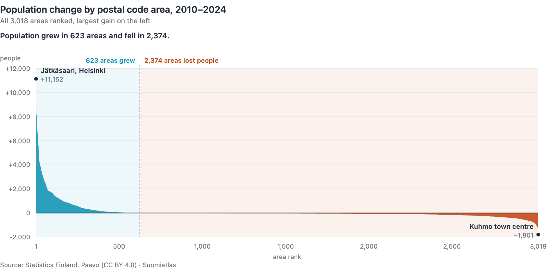
The combined population of Finland's postal code areas grew by 241,311 people between 2010 and 2024. Of the country's 3,018 postal code areas, 623 grew and 2,374 shrank. The remaining 21 ended where they started, and 13 of those had no residents in either year.
Finland is growing, and four areas in five are shrinking. Both are true at once.
51 areas account for the whole net increase
Leave out the 51 areas that gained the most people, and the arithmetic very nearly cancels: the other 572 growing areas gained 299,237 people, and the 2,374 shrinking areas lost 299,959. The difference between those two is 722 people — 0.2% of either figure.
What is left is the top of the list. Those 51 areas — 1.7% of all areas — added 242,033 people between them, slightly more than the 241,311 that all 3,018 areas gained together. This does not mean growth happened in only 51 places: 623 areas grew. It means the other 2,967 areas sum to −722 people.
This is accounting, not cause and effect. The figures show two nearly equal flows offsetting each other; they do not show anyone moving from a shrinking area to a growing one. Migration is only one component of population change alongside births, deaths and immigration, and this dataset does not separate them.
Growth is deep and narrow
| Area | 2010 | 2024 | Change |
|---|---|---|---|
| Jätkäsaari, Helsinki | 0 | 11,152 | +11,152 |
| Kivistö, Vantaa | 2,578 | 13,583 | +11,005 |
| Tikkurila, Vantaa | 16,711 | 24,875 | +8,164 |
| Niittykumpu, Espoo | 6,285 | 14,415 | +8,130 |
| Vuores, Tampere | 215 | 8,333 | +8,118 |
| Etelä-Leppävaara, Espoo | 10,035 | 17,336 | +7,301 |
The top of the list is a list of construction projects, and the same Paavo dataset shows it. Jätkäsaari had no dwellings and no residents in 2010; by 2024 it had 6,372 dwellings. Kivistö went from 974 dwellings to 8,374, and Vuores from 99 to 4,582. An area's population can only grow where something has been built, and at the top of the list that shows through directly.
Of the 51 areas that gained the most people, 38 are in Finland's six largest cities: Helsinki, Espoo, Vantaa, Tampere, Turku and Oulu. Across all 623 growing areas, 212 are in those six municipalities, and the growing areas are spread over 136 of the 308 municipalities in the current classification.
Decline is shallow and wide
The largest loss in people anywhere in the country was Kuhmo town centre, at −1,801. That is smaller than the increase in any of the ten areas that gained the most people.
The median shrinking area lost 61 people across the whole 14 years — about four people a year. In total, 1,812 of the 3,018 areas changed by 100 people or fewer in either direction. Decline mostly does not look like a collapse in any single area: of the 2,374 areas that shrank, 1,595 lost fewer than 100 people over the whole period.
Even so, of the 5,557,765 people counted in these areas in 2024, 3,207,516 — 57.7% — lived in one of the 623 that had grown.
The two facts are stranger together than apart. The 2,374 shrinking areas cover 303,161 km² — 89.8% of Finland's surface area, because they are the large rural ones while the growing areas are small and urban. So decline covers nine tenths of the country, and a majority of Finns live somewhere that is growing.
What the figure counts
Population means people permanently resident in the area on 31 December. The figures come from Statistics Finland's Paavo time series, where the year is the statistical year rather than Paavo's publishing year, so the 2024 figure is the situation on 31 December 2024.
Every year is computed on the same postal code area classification, the current one. That is what makes the comparison possible: had 2010 been computed on the boundaries of its own time, a boundary change would appear here as an area growing or shrinking. Statistics Finland has published the time series this way since 2023.
Paavo's national total for 2024, 5,557,765, is lower than Finland's official population of 5,635,971. Paavo excludes people whose location within their municipality is unknown: people in institutions without coordinates, Finnish nationals temporarily abroad, and others without coordinates — approximately one percent of the population, in Statistics Finland's own description.
The undercount is not just a matter of level. The group without coordinates grew between the two years: 58,822 people missing in 2010, 78,206 in 2024 — 1.1% of the official total, then 1.4%. So the change is understated as well. Finland's official population rose by 260,695 between 2010 and 2024 (5,375,276 → 5,635,971), against the 241,311 counted here, and the 19,384 difference is 8.0% of the change this article reports. The figures here are sums over postal code areas: comparing areas against each other is sound, but as a measure of national growth the number is about 8% too low.
No percentage change is given for areas that had zero residents in 2010, because there is nothing to divide by. Jätkäsaari is one of those, which is why it appears here as the largest increase in people rather than in percent.
Check it yourself
The figures for all 3,018 areas are downloadable as CSV above: postal code, area name, municipality, population in 2010 and 2024, change in people and change in percent. Rows are ordered by change, largest gain first. The chart is drawn from this same file, so the article and the figure cannot disagree.
The API gives the same ordering:
https://suomiatlas.com/api/v1/rankings?variableCode=he_vakiy&year=2024&limit=10. That lists the
largest areas in 2024, not those that gained the most — computing a change takes two years, and here
they are 2010 and 2024.
The dwelling counts and surface areas quoted above are not in this CSV. They come from the same
Paavo dataset, variables ra_asunn and pinta_ala, and the API returns both:
https://suomiatlas.com/api/v1/postal-codes/00220/stats?year=2024 gives Jätkäsaari an ra_asunn
of 6372 and a pinta_ala of 738,859 m². Dwelling counts are withheld for areas with only one
building, one residential building, or fewer than ten dwellings, so unlike population they do not
cover all 3,018 areas. Surface area is published for every area and excludes sea but includes inland
water, which is why the 3,018 areas total 337,628 km² rather than Finland's 303,900 km² of land.
Source: Statistics Finland, Paavo open data by postal code area (CC BY 4.0). The official population figures are from a different Statistics Finland table, StatFin 11ra, key figures on population by region. Both years for all 3,018 areas were verified against Statistics Finland's API on 28 August 2026.
Analysis: Suomiatlas. Questions and corrections: [email protected]